
Journal of Systems Engineering and Electronics ›› 2021, Vol. 32 ›› Issue (6): 1284-1303.doi: 10.23919/JSEE.2021.000109
• RADAR DIFFERENTIAL INTERFEROMETRY TECHNIQUES AND APPLICATIONS • Previous Articles Next Articles
Honglei YANG1,*( ), Qiao JIANG2(), Jianfeng HAN1(), Ki-Yeob KANG3, Junhuan PENG1()
Received:2021-03-10
Online:2022-01-05
Published:2022-01-05
Contact:
Honglei YANG
E-mail:hongleiyang@cugb.edu.cn;2640105418@qq.com;924247310@qq.com;pengjunhuan@163.com
About author:Supported by:Honglei YANG, Qiao JIANG, Jianfeng HAN, Ki-Yeob KANG, Junhuan PENG. InSAR measurements of surface deformation over permafrost on Fenghuoshan Mountains section, Qinghai-Tibet Plateau[J]. Journal of Systems Engineering and Electronics, 2021, 32(6): 1284-1303.
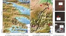
Fig 1
The map of the study area"

Table 1
Basic parameters of SAR images"
| Number | Sensor | Acquisition time (year-month-day) | Perpendicular baseline/m |
| 1 | PALSAR | 2007-01-17 | 0 |
| 2 | PALSAR | 2007-03-04 | 1 839.02 |
| 3 | PALSAR | 2007-07-20 | 2 527.09 |
| 4 | PALSAR | 2007-09-04 | 2 708.44 |
| 5 | PALSAR | 2007-10-20 | 2 925.88 |
| 6 | PALSAR | 2008-01-20 | 3 484.94 |
| 7 | PALSAR | 2008-03-06 | 4 067.51 |
| 8 | PALSAR | 2008-04-21 | 4 518.52 |
| 9 | PALSAR | 2008-06-06 | 4 462.98 |
| 10 | PALSAR | 2008-07-22 | 1 516.82 |
| 11 | PALSAR | 2008-09-06 | ?663.26 |
| 12 | PALSAR | 2008-10-22 | ?91.87 |
| 13 | PALSAR | 2009-01-22 | 498.06 |
| 14 | PALSAR | 2009-03-09 | 904.87 |
| 15 | PALSAR | 2009-07-25 | 1 131.38 |
| 16 | PALSAR | 2009-09-09 | 1 641.92 |
| 17 | PALSAR | 2009-10-25 | 1 898.51 |
| 18 | PALSAR | 2010-01-25 | 2 612.77 |
| 19 | PALSAR | 2010-07-28 | 3 499.58 |
| 20 | PALSAR | 2010-09-12 | 3 551.67 |
| 21 | PALSAR | 2010-10-28 | 3 968.39 |
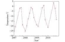
Fig 2
Average night temperature between 2007 and 2010"
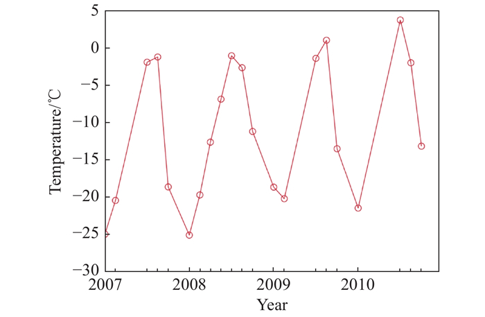
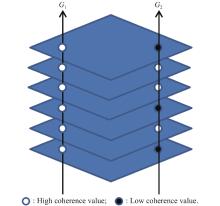
Fig 3
Schematic of the high coherence point and intermittent high coherence point"
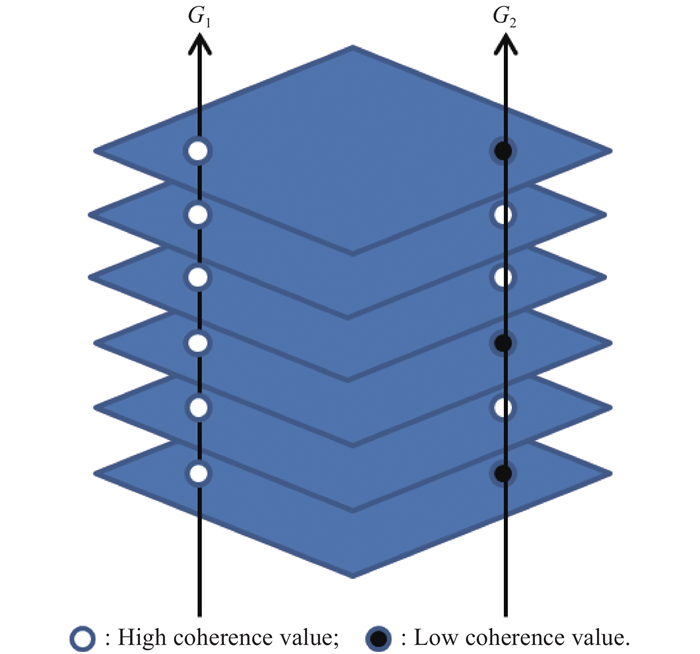
Fig 4
Flowchart of the proposed ICSBAS technique"
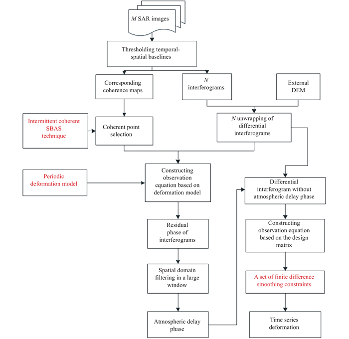
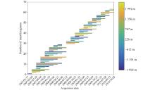
Fig 5
Perpendicular spatial baselines and temporal intervals of the selected InSAR image pairs"
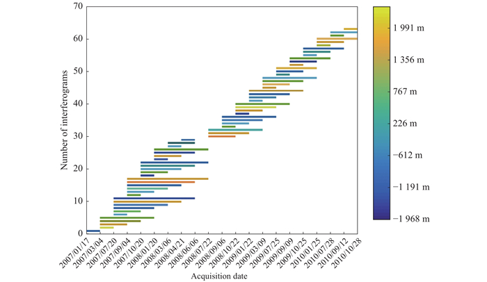
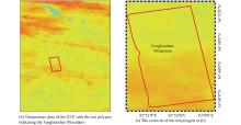
Fig 6
Temperature data"
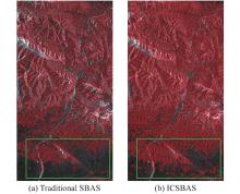
Fig 7
High CP selected by traditional SBAS and ICSBAS"
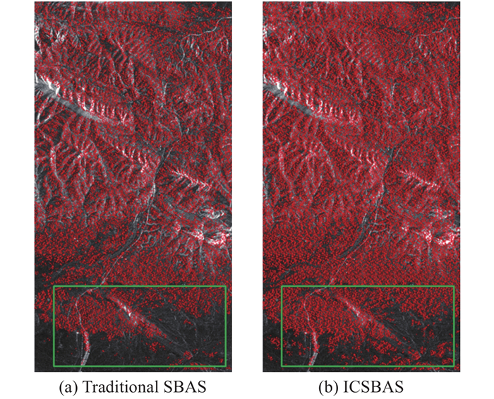
Fig 8
Coefficients of the improved deformation model estimated by (17)"

Fig 9
High-resolution optical images of the three significant deformation areas of Fig. 8"
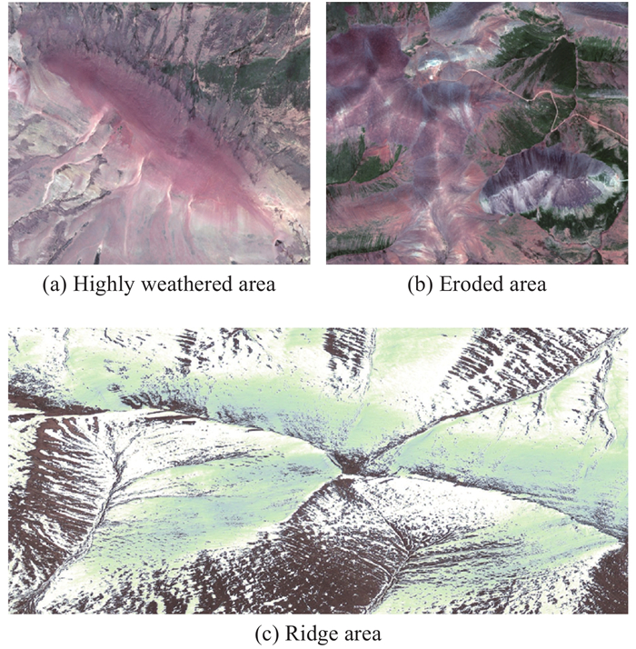
Fig 10
Time series deformation of the study area relative to the InSAR image obtained on January 17, 2007"
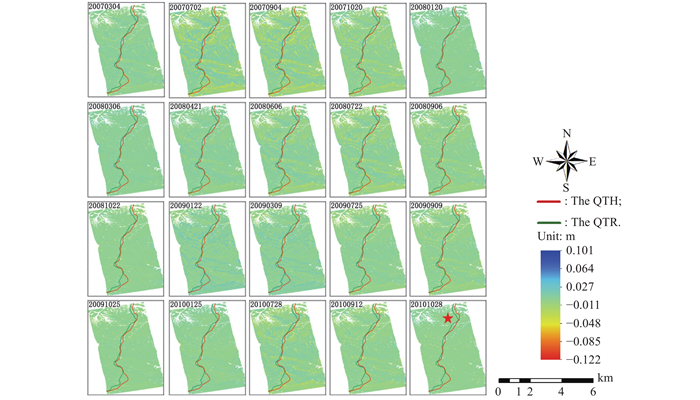
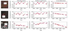
Fig 11
Time series deformation of three typical feature points from 2007 to 2010"
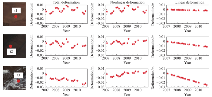
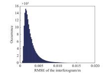
Fig 12
RMSE of the interferogram residual"

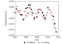
Fig 13
Time series comparison between ICSBAS results and leveling data"
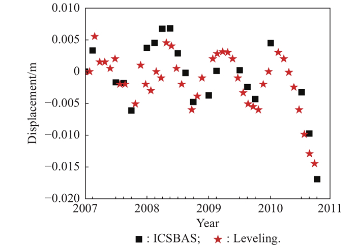

Fig 14
Correlation analysis between deformation and temperature"
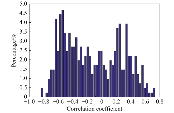
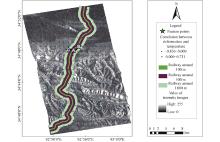
Fig 15
Resampling of temperature and deformation"
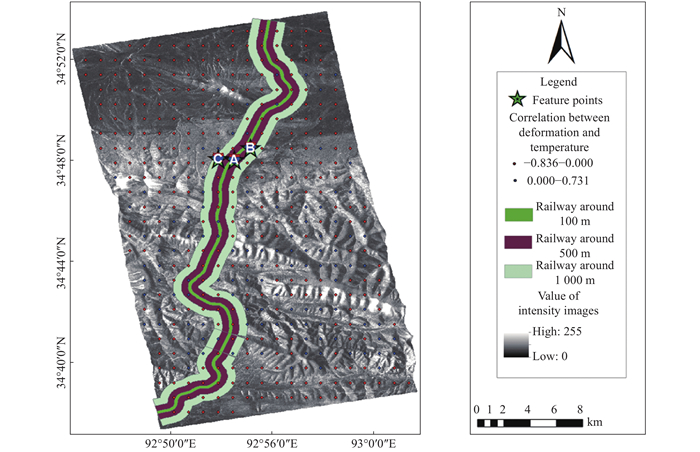
Table 2
Correlation ratio between temperature and deformation in the area with different distances from the QTR"
| Distance from the QTR | Positive correlation ratio/% | Negative correlation ratio/% |
| Within 100 m | 62.5 | 37.5 |
| 100?500 m | 20 | 80 |
| Larger than 1 000 m | 7.5 | 92.5 |
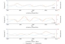
Fig 16
Correlation between temperature and deformation over the three points (marked by A, B and C, respectively, in Fig. 15) in the areas with a distance of 100 m, 500 m and 1 000 m from the QTR"
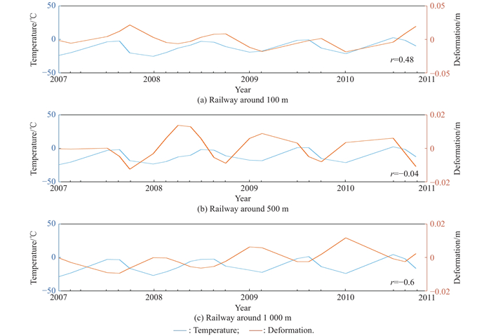
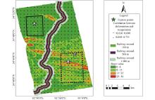
Fig 17
Slope map of the study area"

Table 3
Correlation ratio between the temperature and deformation with different slopes"
| Slope | Positive correlation ratio/% | Negative correlation ratio/% |
| 0?8 | 9.33 | 90.67 |
| 8?36 | 38.1 | 61.9 |
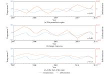
Fig 18
Correlation between temperature and deformation over the three points (marked by A, B and C, respectively, in Fig. 17) located in the flat permafrost area, the upper part of the hillside, and the lower part of the hillside"
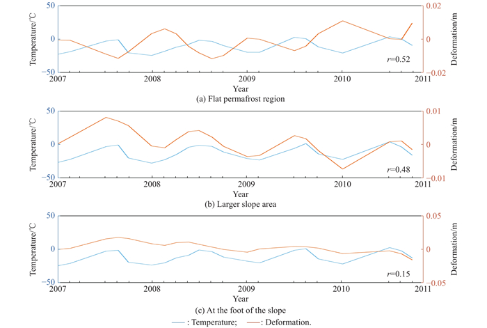

Fig 19
Aspect"
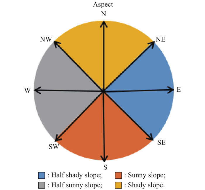
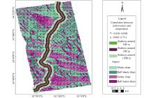
Fig 20
Aspect map of study area"

Table 4
Correlation ratio between the temperature and deformation of different aspects % "
| Slope | Positive correlation ratio | Negative correlation ratio |
| Shady slope | 19 | 81 |
| Sunny slope | 34.3 | 65.7 |
| 1 | ZHOU Y W, GUO D X Principle characteristics of permafrost in China. Journal of Glaciology and Geocryology, 1982, 4 (1): 1- 19. |
| 2 |
NELSON F E, ANISIMOV O A, SHIKLOMANOV N I Subsidence risk from thawing permafrost. Nature, 2001, 410 (6831): 889- 890.
doi: 10.1038/35073746 |
| 3 |
SMITH S, BURGESS M, RISEBOROUGH D, et al Recent trends from Canadian permafrost thermal monitoring network sites. Permafrost and Periglacial Process, 2005, 16, 19- 30.
doi: 10.1002/ppp.511 |
| 4 | YU Q H, LIU Y Z, TONG C J, et al Analysis of the subgrade deformation of the Qinghai-Tibetan Highway. Journal of Glaciology and Geocryology, 2002, 24 (5): 623- 627. |
| 5 |
JONATHON D L, HEATH S, MICHAEL T, et al Application of differential global positioning systems to monitor frost heave and thaw settlement in tundra environments. Permafrost and Periglacial Processes, 2003, 14, 349- 357.
doi: 10.1002/ppp.466 |
| 6 | SCOTT W, SELLMANN P, HUNTER J Geophysics in the study of permafrost. Geophysicists Investigation in Geophysics, 1990, 5, 355- 384. |
| 7 |
HINKEL K, DOOLITTLE J, BOCKHEIM J, et al Detection of subsurface permafrost features with ground-penetrating radar, barrow, alaska. Permafrost Periglacial Process, 2001, 12, 179- 190.
doi: 10.1002/ppp.369 |
| 8 |
MASSONNE D, ROSSI M, CARMONA C, et al The displacement field of the landers earthquake mapped by radar interferometry. Nature, 1993, 364 (6433): 138- 142.
doi: 10.1038/364138a0 |
| 9 | WANG Z, LI S Detection of winter frost heaving of the active layer of arctic permafrost using SAR differential interferograms. Proc. of the IEEE International Geoscience and Remote Sensing Symposium, 1999, 4, 1946- 1948. |
| 10 | LI Z, LI X W, LIU Y Z, et al Detecting the displacement field of thaw settlement by means of SAR interferometry. Journal of Glaciology and Geocryology, 2004, 26 (4): 389- 396. |
| 11 | BUTTERWORTH C. Measuring seasonal permafrost deformation with differential interferometric synthetic aperture radar. Calgary, Canada: University of Calgary, 2008. |
| 12 | XIE C, LI Z, LI X W A study of deformation in permafrost regions of Qinghai-Tibet plateau based on ALOS/PALSAR D-InSAR interferometry. Remote Sensing for Land and Resources, 2008, 30 (3): 15- 19. |
| 13 | WANG P. Using D-InSAR to monitor the motion of frozen ground in Qinghai-Tibet Plateau. Changsha, China: Centrol South University, 2008. (in Chinese) |
| 14 | HU B, WANG H S, JIA L L DInSAR technology to monitor deformation of Qinghai-Tibet Plateau permafrost experimental study. Geodesy and Geodynamics, 2010, 30 (5): 53- 56. |
| 15 |
FERRETI A, PRATI C, ROCCA F Non-linear subsidence rate estimation using permanent scatterers in differential SAR interferometry. IEEE Trans. on Geoscience and Remote Sensing, 2000, 38 (5): 2202- 2212.
doi: 10.1109/36.868878 |
| 16 |
BERARDINO P, FORNARO G, LANARI R, et al A new algorithm for surface deformation monitoring based on small baseline differential SAR interferograms. IEEE Trans. on Geoscience and Remote Sensing, 2002, 40 (11): 2375- 2383.
doi: 10.1109/TGRS.2002.803792 |
| 17 | LIU L, ZHANG T J, WAHR J et al. InSAR measurements of surface deformation over permafrost on the North Slope of Alaska. Journal of Geophysical Research Earth Surface, 2010, 115(F3). DOI: 10.1029/2009JF001547. |
| 18 |
SHORT N, BRISCO B, COUTURE N, et al A comparison of TerraSAR-X, RADARSAT-2 and ALOS-PALSAR interferometry for monitoring permafrost environments, case study from Herschel Island, Canada. Remote Sensing of Environment, 2011, 115 (12): 3491- 3506.
doi: 10.1016/j.rse.2011.08.012 |
| 19 |
CHEN F L, LIN H, LI Z, et al Interaction between permafrost and infrastructure along the Qinghai-Tibet Railway detected via jointly analysis of C- and L-band small baseline SAR interferometry. Remote Sensing of Environment, 2012, 123, 532- 540.
doi: 10.1016/j.rse.2012.04.020 |
| 20 | LIU L, SCHAEFER K, ZHANG T J, et al Estimating 1992–2000 average active layer thickness on the Alaskan North Slope from remotely sensed surface subsidence. Journal of Geophysical Research Earth Surface, 2012, 117, 14. |
| 21 | LI S S, LI Z W, HU J, et al Investigation of the seasonal oscillation of the permafrost over Qinghai-Tibet Plateau with SBAS-InSAR algorithm. Chinese Journal of Geophysics, 2013, 56 (5): 1476- 1486. |
| 22 | LIU L, SCHAEFER K, GUSMEROLI A, et al Seasonal thaw settlement at drained thermokarst lake basins, Arctic Alaska. The Cryosphere, 2014, 8 (6): 5793- 5822. |
| 23 |
SHORT N, LEBLANC A M, SLADEN W, et al RADARSAT-2 D-InSAR for ground displacement in permafrost terrain, validation from Iqaluit Airport, Baffin Island, Canada. Remote Sensing of Environment, 2014, 141, 40- 51.
doi: 10.1016/j.rse.2013.10.016 |
| 24 |
SCHAEFER K, LIU L, PARSEKIAN A, et al Remotely sensed active layer thickness (ReSALT) at Barrow, Alaska using interferometric synthetic aperture radar. Remote Sensing, 2015, 7 (4): 3735- 3759.
doi: 10.3390/rs70403735 |
| 25 |
ZHAO R, LI Z W, FENG G C, et al Monitoring surface deformation over permafrost with an improved SBAS-InSAR algorithm: with emphasis on climatic factors modeling. Remote Sensing of Environment, 2016, 184, 276- 287.
doi: 10.1016/j.rse.2016.07.019 |
| 26 | ZHANG Y H, WU H A, SUN G T Deformation model of time series interferometric SAR techniques. Acta Geodaetica et Cartographica Sinica, 2012, 41 (6): 864- 869. |
| 27 |
WANG C, ZHANG Z J, ZHANG H Seasonal deformation features on Qinghai-Tibet railway observed using time-series InSAR technique with high-resolution TerraSAR-X images. Remote Sensing Letters, 2017, 8 (1): 1- 10.
doi: 10.1080/2150704X.2016.1225170 |
| 28 | CHEN Y X, JIANG L M, LIANG L L, et al Monitoring permafrost deformation in the upstream Heihe River, Qilian Mountain by using multi temporal Sentinel INSAR dataset. Chinese Journal of Geophysics, 2019, 62 (7): 2441- 2454. |
| 29 |
HUANG S B, CHANG Z Q, XIE C Deformation monitoring of frozen soil in salt lake area based on SBAS-InSAR. Advances in Geosciences, 2020, 10 (2): 100- 120.
doi: 10.12677/AG.2020.102011 |
| 30 | CHENG J, WANG T, ZHU Z R, et al Research on subgrade defects of Fenghuoshan section on Qinghai-Tibet railway and countermeasures. Railway Standard Design, 2015, 8 (59): 14- 17. |
| 31 |
COLESANTI C, FERRETTI A, NOVALI F, et al SAR monitoring of progressive and seasonal ground deformation using the permanent scatterers technique. IEEE Trans. on Geoscience and Remote Sensing, 2003, 41 (7): 1685- 1701.
doi: 10.1109/TGRS.2003.813278 |
| 32 |
KAMPES B M, HANSEEN R F Ambiguity resolution for permanent scatterer interferometry. IEEE Trans. on Geoscience and Remote Sensing, 2004, 42 (11): 2446- 2453.
doi: 10.1109/TGRS.2004.835222 |
| 33 |
YANG H L, PENG J H, WANG B C, et al Ground deformation monitoring of Zhengzhou city from 2012 to 2013 using an improved IPTA. Natural Hazards, 2016, 80, 1- 17.
doi: 10.1007/s11069-015-1953-x |
| 34 | SCHMID T, DAVID A. Time-dependent land uplift and subsidence in the Santa Clara Valley, California. Journal of Geophysical Research Solid Earth, 2003, 108(B9): 2416. |
| 35 |
BROWN C G, SARABANDI K, PIERCE L E Validation of the shuttle radar topography mission height data. IEEE Trans. on Geoscience and Remote Sensing, 2005, 43 (8): 1707- 1715.
doi: 10.1109/TGRS.2005.851789 |
| 36 |
LI Z W, DING X L, HUANG C, et al Improved filtering parameter determination for the Goldstein radar interferogram filter. ISPRS Journal of Photogrammetry and Remote Sensing, 2008, 63 (6): 621- 634.
doi: 10.1016/j.isprsjprs.2008.03.001 |
| 37 | COSTANTINI M, ROSEN P A generalized phase unwrapping approach for sparse data. Proc. of the IEEE International Geoscience & Remote Sensing Symposium, 1999, 1 (10): 267- 269. |
| 38 | GARBALLO G F, FIEGUTH P W Probabilistic cost functions for network flow phase unwrapping. IEEE Trans. on Geoscience and Remote Sensing, 2001, 38 (5): 2192- 2201. |
| 39 | ZHANG L X Regularity of ground temperature variation in Qinhgai-Tibet Plateau permafrost region and its effect on subgrade stability. China Railway Science, 2000, 21 (1): 37- 47. |
| 40 | YUAN S C, ZHANG L X, HAN L M, et al Influences of environmental conditions on construction safety reliability of Qinghai-Tibet railway in permafrost region. Journal of Engineering Geology, 2006, 14 (4): 433- 437. |
| 41 | DONG C H, ZHAO X Q Analysis on subgrade deformation features and influence factors in permafrost regions on Qinghai-Tibet Railway. Railway Standard Design, 2013, 6, 5- 8. |
| 42 | YANG X D. The study of the subgrade deformation and characteristic over permafrost. Shaanxi, China: Xi’an Jiaotong University, 1996. |
| 43 | WU Q B, ZHU Y L, SHI B Study of frozen soil environment relating to engineering activities. Journal of Glaciology and Geocryology, 2001, 23 (2): 200- 207. |
| 44 | SUN Z, WANG L, BAI M, et al Finite element analysis on temperature field of Qinghai-Tibet Railway embankment on permafrost. Chinese Journal of Rock Mechanics and Engineering, 2004, 23 (20): 3454- 3459. |
| 45 | CHOU Y L, SHENG Y, MA W, et al Calculation of difference in temperature between sunny slope and shady slope along railways in permafrost regions in Qinghai-Tibet plateau. Chinese Journal of Rock Mechanics and Engineering, 2007, 26 (2): 4102- 4107. |
| No related articles found! |
| Viewed | ||||||
|
Full text |
|
|||||
|
Abstract |
|
|||||