
Journal of Systems Engineering and Electronics ›› 2022, Vol. 33 ›› Issue (4): 896-906.doi: 10.23919/JSEE.2022.000087
• DEFENCE ELECTRONICS TECHNOLOGY • Previous Articles Next Articles
Hao FENG1( ), Jianzhong WU2,3,4(), Lu ZHANG1,*(), Mingsheng LIAO1()
Received:2021-12-03
Online:2022-08-30
Published:2022-08-30
Contact:
Lu ZHANG
E-mail:fengh@whu.edu.cn;wjzhongsh@163.com;luzhang@whu.edu.cn;liao@whu.edu.cn
About author:Supported by:Hao FENG, Jianzhong WU, Lu ZHANG, Mingsheng LIAO. Unsupervised change detection of man-made objects using coherent and incoherent features of multi-temporal SAR images[J]. Journal of Systems Engineering and Electronics, 2022, 33(4): 896-906.
Add to citation manager EndNote|Reference Manager|ProCite|BibTeX|RefWorks
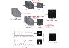
Fig 1
Processing chain of the proposed framework"
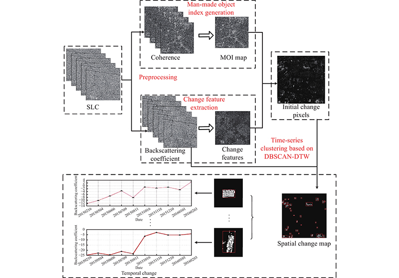
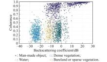
Fig 2
Distribution of coherent and incoherent characteristics of main ground objects in urban scene"
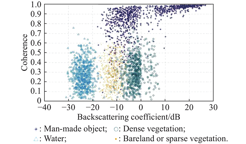
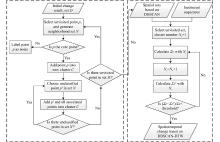
Fig 3
Flow chart of the improved DBSCAN-DTW"
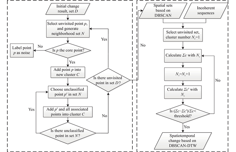
Fig 4
Overview of the study area"
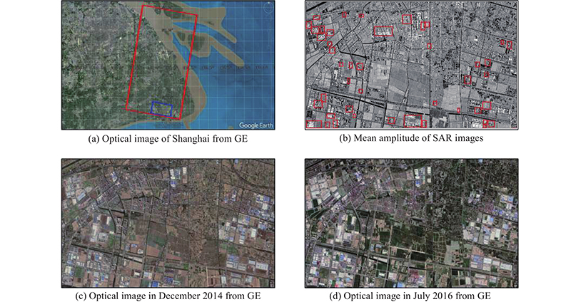
Table 1
Basic parameters of TerraSAR-X datasets"
| Parameter | TerraSAR-X dataset |
| Acquisition date (YYYYMMDD) | 20150216 20150504 |
| 20150606 20150709 | |
| 20150811 20151016 | |
| 20151118 20151210 | |
| 20160101 20160203 | |
| Imaging mode | Stripmap |
| Polarization | VV |
| Pass direction | Descending |
| Incident angle/(°) | 41.06 |
| Slant range spacing/m | 1.36 |
| Azimuth spacing/m | 1.89 |
Table 2
Parameter settings for the experimental setup"
| Parameter | Value |
| Window size of enhanced-Lee filtering | 3×3 |
| Window size of coherence estimation | 3×3 |
| Threshold of change feature | 0.3 |
| Threshold of MOI | 0.6 |
| (?, MinPts) | (20,40) |
| Threshold of iterative convergence | 0.25 |
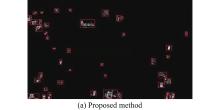
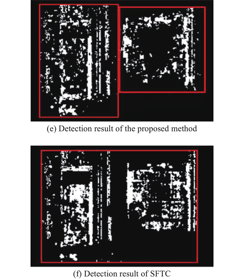
Fig 5
"
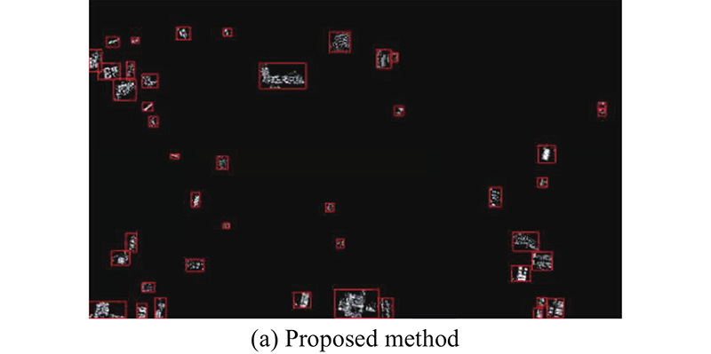
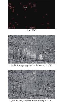
Fig 5
Spatial change detection results and reference SAR images"
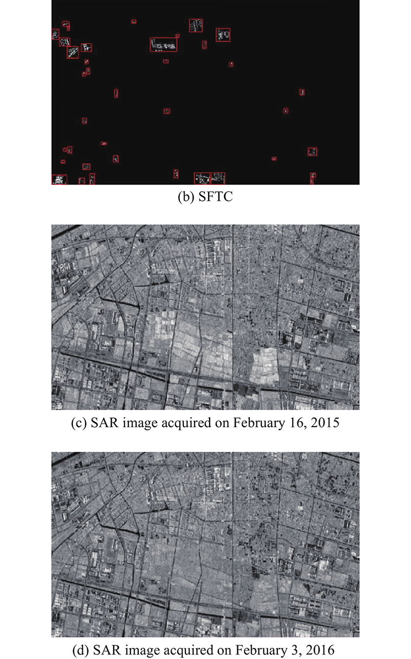
Table 3
Evaluation indicators of two methods"
| Method | PR | ACC | RE | KAPPA |
| Proposed method | 0.905 | 0.815 | 0.864 | 0.675 |
| SFTC | 0.829 | 0.611 | 0.659 | 0.593 |
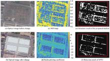
Fig 6
Example of missed detection"
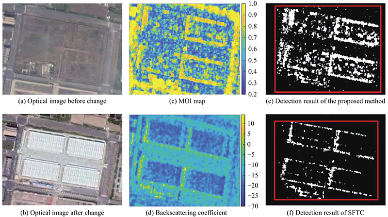
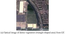
Fig 7
"
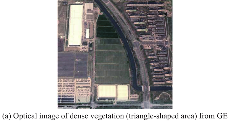
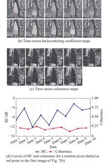
Fig 7
Example of false alarm"
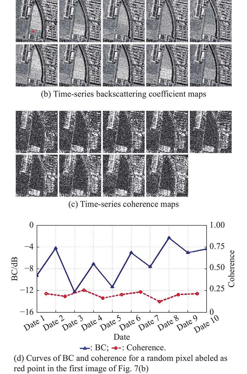
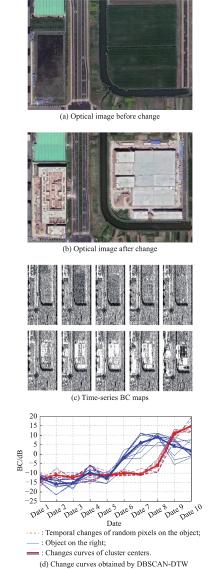
Fig 8
"
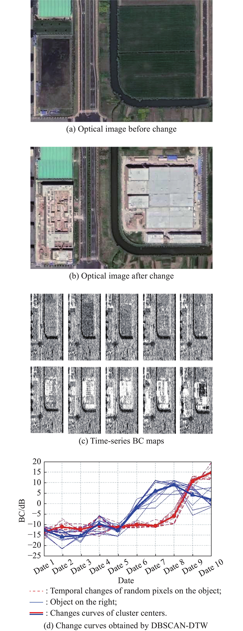
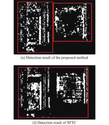
Fig 8
Example of temporal clustering effects"
| 1 | ZHANG W W, LI J, ZHANG F, et al. Unsupervised change detection of multispectral images based on PCA and low-rank prior. IEEE Geoscience and Remote Sensing Letters, 2021. DOI: 10.1109/LGRS.2021.3090407. |
| 2 |
HAO M, ZHOU M C, CAI L P An improved graph-cut-based unsupervised change detection method for multispectral remote sensing images. International Journal of Remote Sensing, 2021, 42 (11): 4005- 4022.
doi: 10.1080/01431161.2021.1881182 |
| 3 |
SAHA S, BOVOLO F, BRUZZONE L Building change detection in VHR SAR images via unsupervised deep transcoding. IEEE Trans. on Geoscience and Remote Sensing, 2021, 59 (3): 1917- 1929.
doi: 10.1109/TGRS.2020.3000296 |
| 4 |
MIAN A, COLLAS A, BRELOY A, et al Robust low-rank change detection for multivariate SAR image time series. IEEE Journal of Selected Topics in Applied Earth Observations and Remote Sensing, 2020, 13, 3545- 3556.
doi: 10.1109/JSTARS.2020.2999615 |
| 5 |
RIGNOT E J M, ZYL J J V Change detection techniques for ERS-1 SAR data. IEEE Trans. on Geoscience and Remote Sensing, 1993, 31 (4): 896- 906.
doi: 10.1109/36.239913 |
| 6 |
HU H T, BAN Y F Unsupervised change detection in multitemporal SAR images over large urban areas. IEEE Journal of Selected Topics in Applied Earth Observations and Remote Sensing, 2014, 7 (8): 3248- 3261.
doi: 10.1109/JSTARS.2014.2344017 |
| 7 |
CUI S Y, LUO C F Feature-based non-parametric estimation of Kullback–Leibler divergence for SAR image change detection. Remote Sensing Letters, 2016, 7 (11): 1102- 1111.
doi: 10.1080/2150704X.2016.1212418 |
| 8 |
XIONG B L, CHEN J M, KUANG G Y A change detection measure based on a likelihood ratio and statistical properties of SAR intensity images. Remote Sensing Letters, 2012, 3 (3): 267- 275.
doi: 10.1080/01431161.2011.572093 |
| 9 |
GAMBA P, DELL’ACQUA F, LISINI G Change detection of multitemporal SAR data in urban areas combining feature-based and pixel-based techniques. IEEE Trans. on Geoscience and Remote Sensing, 2006, 44 (10): 2820- 2827.
doi: 10.1109/TGRS.2006.879498 |
| 10 |
MARIN C, BOVOLO F, BRUZZONE L Building change detection in multitemporal very high resolution SAR images. IEEE Trans. on Geoscience and Remote Sensing, 2015, 53 (5): 2664- 2682.
doi: 10.1109/TGRS.2014.2363548 |
| 11 | HONG C, SUN G Q, LING F L Urban dynamic change detection in southeastern China based on interferometric SAR. Proc. of the IEEE International Geoscience and Remote Sensing Symposium, 2009, 3, 432- 435. |
| 12 |
LIAO M S, JIANG L M, LIN H, et al Urban change detection based on coherence and intensity characteristics of SAR imagery. Photogrammetric Engineering and Remote Sensing, 2008, 74 (8): 999- 1006.
doi: 10.14358/PERS.74.8.999 |
| 13 |
WANG Y F, ZHAO F F, CHENG L, et al Framework for monitoring the conversion of cultivated land to construction land using SAR image time series. Remote Sensing Letters, 2015, 6 (10): 794- 803.
doi: 10.1080/2150704X.2015.1081304 |
| 14 |
WASHAY P, BALZ T, MOHAMADI B Coherence change-detection with Sentinel-1 for natural and anthropogenic disaster monitoring in urban areas. Remote Sensing, 2018, 10 (7): 1026.
doi: 10.3390/rs10071026 |
| 15 |
KOENIGUER E C, NICOLAS J M Change detection based on the coefficient of variation in SAR time-series of urban areas. Remote Sensing, 2020, 12 (13): 2089.
doi: 10.3390/rs12132089 |
| 16 |
ZHANG K Y, FU X K, LYU X L, et al Unsupervised multitemporal building change detection framework based on cosegmentation using time-series SAR. Remote Sensing, 2021, 13 (3): 471.
doi: 10.3390/rs13030471 |
| 17 |
YUAN J L, LYU X L, DOU F J, et al Change analysis in urban areas based on statistical features and temporal clustering using TerraSAR-X time-series images. Remote Sensing, 2019, 11 (8): 926.
doi: 10.3390/rs11080926 |
| 18 |
ZHANG X Z, SU H, ZHANG C, et al Robust unsupervised small area change detection from SAR imagery using deep learning. ISPRS Journal of Photogrammetry and Remote Sensing, 2021, 173, 79- 94.
doi: 10.1016/j.isprsjprs.2021.01.004 |
| 19 |
GONG M G, YANG H L, ZHANG P Z Feature learning and change feature classification based on deep learning for ternary change detection in SAR images. ISPRS Journal of Photogrammetry and Remote Sensing, 2017, 129, 212- 225.
doi: 10.1016/j.isprsjprs.2017.05.001 |
| 20 |
LIU F, JIAO L C, TANG X, et al Local restricted convolutional neural network for change detection in polarimetric SAR images. IEEE Trans. on Neural Networks and Learning Systems, 2019, 30 (3): 818- 833.
doi: 10.1109/TNNLS.2018.2847309 |
| 21 |
LI X H, DU Z S, HUANG Y Y, et al A deep translation (GAN) based change detection network for optical and SAR remote sensing images. ISPRS Journal of Photogrammetry and Remote Sensing, 2021, 179, 14- 34.
doi: 10.1016/j.isprsjprs.2021.07.007 |
| 22 |
LOPES A, TOUZI R, NEZRY E Adaptive speckle filters and scene heterogeneity. IEEE Trans. on Geoscience and Remote Sensing, 1990, 28 (6): 992- 1000.
doi: 10.1109/36.62623 |
| 23 | AIRBUS. Calculation of beta naught and sigma naught for TerraSAR-X data. https://www.intelligence-airbusds.com/en/228-terrasar-x-technical-documents. |
| 24 |
MAUS V, CAMARA G, CARTAXO R, et al A time-weighted dynamic time warping method for land-use and land-cover mapping. IEEE Journal of Selected Topics in Applied Earth Observations and Remote Sensing, 2016, 9 (8): 3729- 3739.
doi: 10.1109/JSTARS.2016.2517118 |
| 25 |
YAN J N, WANG L Z, SONG W J, et al A time-series classification approach based on change detection for rapid land cover mapping. ISPRS Journal of Photogrammetry and Remote Sensing, 2019, 158, 249- 262.
doi: 10.1016/j.isprsjprs.2019.10.003 |
| 26 |
CSILLIK O, BELGIU M, ASNER G P, et al Object-based time-constrained dynamic time warping classification of crops using sentinel-2. Remote Sensing, 2019, 11 (10): 1257.
doi: 10.3390/rs11101257 |
| 27 |
PETITJEAN F, INGLADA J, GANCARSKI P Satellite image time series analysis under time warping. IEEE Geoscience and Remote Sensing Letters, 2012, 50 (8): 3081- 3095.
doi: 10.1109/TGRS.2011.2179050 |
| 28 | ESTER M, KRIEGEL H P, SANDER J, et al A density-based algorithm for discovering clusters in large spatial databases with noise. Proc. of the 2nd International Conference on Knowledge Discovery and Data Mining, 1996, 226- 231. |
| 29 |
ZHU L J, WALKER J P, YE N, et al Roughness and vegetation change detection: a pre-processing for soil moisture retrieval from multi-temporal SAR imagery. Remote Sensing of Environment, 2019, 225, 93- 106.
doi: 10.1016/j.rse.2019.02.027 |
| 30 | JUNKE M, HOCH R, DENGEL A On the evaluation of document analysis components by recall, precision, and accuracy. Journal of Natural Products, 1999, 74 (4): 80- 85. |
| [1] | Jinfeng LYU, Fucai LIU, Yaxue REN. Fuzzy identification of nonlinear dynamic system based on selection of important input variables [J]. Journal of Systems Engineering and Electronics, 2022, 33(3): 737-747. |
| [2] | Fengming HU, Jicang WU. Detecting spatio-temporal urban surface changes using identified temporary coherent scatterers [J]. Journal of Systems Engineering and Electronics, 2021, 32(6): 1304-1317. |
| [3] | Zhongxiang CHANG, Zhongbao ZHOU, Feng YAO, Xiaolu LIU. Observation scheduling problem for AEOS with a comprehensive task clustering [J]. Journal of Systems Engineering and Electronics, 2021, 32(2): 347-364. |
| [4] | Xuhao GUI, Junfeng ZHANG, Zihan PENG. Trajectory clustering for arrival aircraft via new trajectory representation [J]. Journal of Systems Engineering and Electronics, 2021, 32(2): 473-486. |
| [5] | Pengcheng GUO, Zheng LIU, Jingjing WANG. Radar group target recognition based on HRRPs and weighted mean shift clustering [J]. Journal of Systems Engineering and Electronics, 2020, 31(6): 1152-1159. |
| [6] | Aref YELGHI, Cemal KÖSE, Asef YELGHI, Amir SHAHKAR. Automatic fuzzy-DBSCAN algorithm for morphological and overlapping datasets [J]. Journal of Systems Engineering and Electronics, 2020, 31(6): 1245-1253. |
| [7] | Gaofeng WU, Kaifang WAN, Xiaoguang GAO, Xiaowei FU. Placement of unmanned aerial vehicles as communication relays in two-tiered multi-agent system: clustering based methods [J]. Journal of Systems Engineering and Electronics, 2020, 31(2): 231-242. |
| [8] | Xiaolong XU, Wen CHEN, Yanfei SUN. Over-sampling algorithm for imbalanced data classification [J]. Journal of Systems Engineering and Electronics, 2019, 30(6): 1182-1191. |
| [9] | Jiayun CHANG, Xiongjun FU, Wen JIANG, Min XIE. Wideband radar detector based on characteristic parameters of echoes [J]. Journal of Systems Engineering and Electronics, 2019, 30(5): 897-904. |
| [10] | Xinglin SHEN, Zhiyong SONG, Hongqi FAN, Qiang FU. Fast density peak-based clustering algorithm for multiple extended target tracking [J]. Journal of Systems Engineering and Electronics, 2019, 30(3): 435-447. |
| [11] | Zhiqiang JIAO, Peiyang YAO, Jieyong ZHANG, Yun ZHONG, Xun WANG. MAV/UAV task coalition phased-formation method [J]. Journal of Systems Engineering and Electronics, 2019, 30(2): 402-414. |
| [12] | Naiming XIE, Bentao SU, Nanlei CHEN. Construction mechanism of whitenization weight function and its application in grey clustering evaluation [J]. Journal of Systems Engineering and Electronics, 2019, 30(1): 121-131. |
| [13] | Ahmed ABDALLA, Mohaned Giess Shokrallah AHMED, Yuan ZHAO, Ying XIONG, Bin TANG. Deceptive jamming suppression in multistatic radar based on coherent clustering [J]. Journal of Systems Engineering and Electronics, 2018, 29(2): 269-277. |
| [14] | Kun Zhang, Weiren Kong, Peipei Liu, Jiao Shi, Yu Lei, Jie Zou, and Min Liu. Partition region-based suppressed fuzzy C-means algorithm [J]. Systems Engineering and Electronics, 2017, 28(5): 996-1008. |
| [15] | Jin Dai, Yi Yan, and Yuhong He. Grey incidence clustering method based on multidimensional dynamic time warping distance [J]. Systems Engineering and Electronics, 2017, 28(5): 946-954. |
| Viewed | ||||||
|
Full text |
|
|||||
|
Abstract |
|
|||||