
Journal of Systems Engineering and Electronics ›› 2022, Vol. 33 ›› Issue (2): 340-344.doi: 10.23919/JSEE.2022.000035
• DEFENCE ELECTRONICS TECHNOLOGY • Previous Articles Next Articles
Margarita ORESHKINA*( ), Maksim STEPANOV(), Alexey KISELEV()
Received:2021-02-19
Accepted:2022-02-10
Online:2022-05-06
Published:2022-05-06
Contact:
Margarita ORESHKINA
E-mail:oreskina.m@yandex.ru;a.kiselev@corp.nstu.ru
About author:Supported by:Margarita ORESHKINA, Maksim STEPANOV, Alexey KISELEV. Digital Earth surface maps for radar ground clutter simulation[J]. Journal of Systems Engineering and Electronics, 2022, 33(2): 340-344.
Add to citation manager EndNote|Reference Manager|ProCite|BibTeX|RefWorks
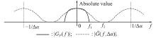
Fig 1
Absolute values of the functions ${{\boldsymbol{G_F}}}({{\boldsymbol{f}}})$ and $\hat{{\boldsymbol{G}}}({\boldsymbol{f}})$ "
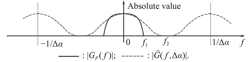
Table 1
Necessary cover azimuth sampling rate for the most common pattern models"
| Antenna pattern approximation | The upper frequency of the spectrum f1 | ||
| ε = 0.001 | ε = 0.01 | ε = 0.1 | |
| | 2.8N/WN05 | 2.3N/WN05 | 1.7N/WN05 |
| | 3.8N/WN00 | 3.4N/WN00 | 2.6N/WN00 |
| | 3.1N/WN00 | 2.9N/WN00 | 2.3NWN00 |
| | 4N/WN00 | 3.6N/WN00 | 2.7N/WN00 |
Fig 2
Ground clutter map"
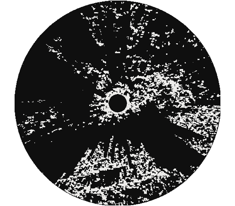
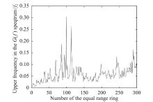
Fig 3
Dependence of the frequency f2 on the number of a ring of equal range for the distribution is shown in the Fig. 2 (ε = 0.1) "

Table 2
Dependence of the gain (9) on the antenna beamwidth"
| Antenna beamwidth in degree | Gain of the method | ||
| 1/(°) | 2/(°) | 3/(°) | |
| Frequency f1 (ε = 0.1) | 0.06 | 0.03 | 0.02 |
| Gain (9) for the Example 1 | 3 | 5.5 | 8 |
| Gain (9) for the Example 2 | ? | 1.25 | 1.6 |
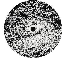
Fig 4
Ground clutter map"
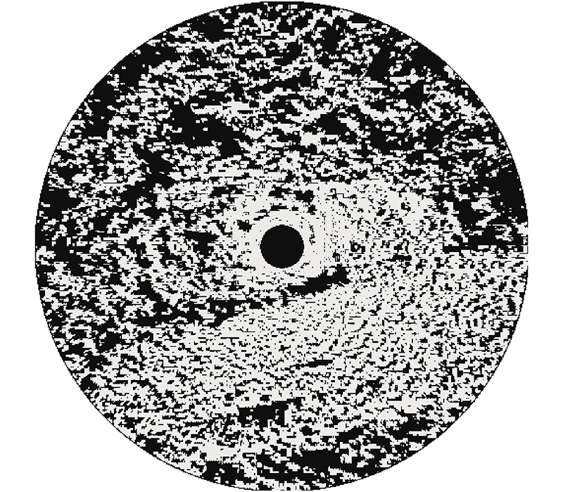
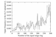
Fig 5
Dependence of the frequency f2 on the number of a ring of equal range for the distribution is shown in Fig. 4 (ε = 0.1) "
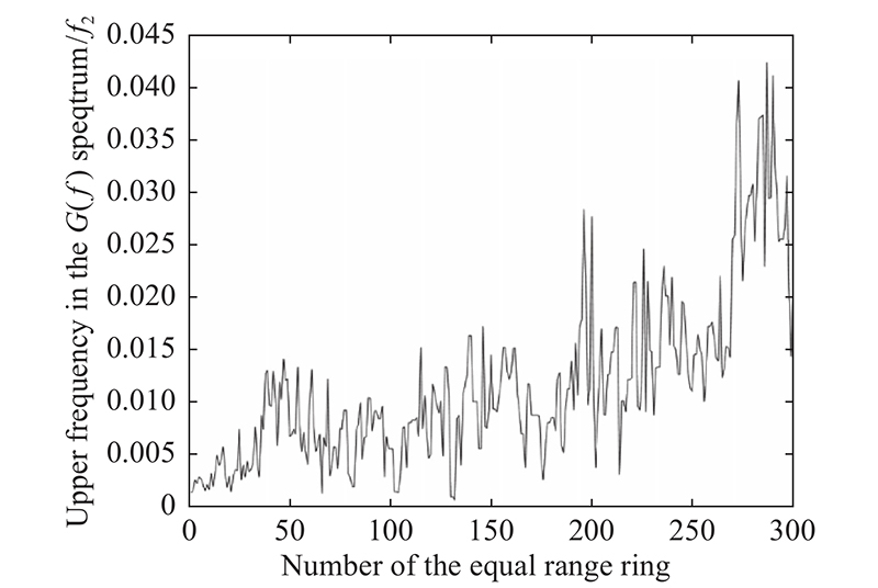
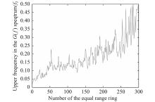
Fig 6
Dependence of the frequency f2 on the number of a ring of equal range for the distribution is shown in Fig. 4 (ε = 0.01) "

Table 3
Dependence of the gain (9) on the antenna beamwidth"
| Antenna beamwidth in degree | Gain of the method | ||
| 1/(°) | 2/(°) | 3/(°) | |
| Frequency f1 (ε = 0.01) | 0.08 | 0.04 | 0.03 |
| Gain (9) for the Example 2 | 3.6 | 6.7 | 8.8 |
| 1 | BILLINGSLEY J B. Low-angle radar land clutter-measurement and empirical models. Norwich: William Andrew Publishing, 2002. |
| 2 | FENG S S, CHEN J Low-angle reflectivity modeling of land clutter. IEEE Geoscience and Remote Sensing Letters, 2006, 254- 258. |
| 3 | RYAN J S, SAVILLE M A, PARK J. Modeling terrain profiles from digital terrain elevation data and national land cover data. Proc. of the SPIE, 2016. DOI: 10.1117/12.2225338. |
| 4 | KULEMIN G P. Millimeter-wave radar targets and clutter. Boston: Artech House, 2003. |
| 5 | GRECO M S, WATTS S. Academic press library in signal processing. New York: Academic Press, 2014. |
| 6 | ORESHKINA M V, KISELEV A V. On the errors arising from the use of discrete surface models for land clutter simulation. Proc. of the XIV International Scientific-Technical Conference on Actual Problems of Electronic Instrument Engineering, 2018. |
| 7 | RICHARDS M A, SCHEER J A, HOLM W A. Principles of modern radar: basic principles. Edison: Scitech Publishing, 2010. |
| 8 | NATANSON F E, REILLY J P, COHEN M N. Radar design principles: signal processing and the environment. Edison: Scitech Publishing, 2004. |
| 9 | BELORUTSKY R Y, NIKULIN A V. The substitution of earth surface by discrete model when imitating echo signal reflected from it. Issues of Radio Electronics, 2012, 4: 134–144. |
| 10 | ORESHKINA M V, KISELEV A V. Discrete model of earth reflectivity for land clutter simulation. Proc. of the International Multi-conference on Engineering, Computer and Information Sciences, 2019: 639–640. |
| 11 | KULEMIN G P, GOROSHKO E A, TARNAVSKY E V. Spatio-temporal characteristics of backscatters from the earth serface. Success in Modern Electronics, 2004, 12: 60–70. (in Russian) |
| 12 | SKOLNIK M I. Radar handbook. 3rd ed. New York: McGrew-Hill, 2008. |
| 13 | TVERSKOY G N, TERENTYEV G N, KHARCHENKO I P. Echo simulators for marine radar. Leningrad: Sydostroenie, 1973. (in Russian) |
| 14 | DARAWANKUL A, JONSON J T. Band-limited exponential correlation function for rough-surface scattering. IEEE Trans. on Geoscience and Remote Sensing, 2007, 45(5): 1198-1206. |
| 15 | HABIBI A. Two dimensional Bayesian estimate of image. Proceedings of the IEEE, 1972, 60(7): 878–883. |
| 16 | GAUR Y N, SRIVASTAVA N. Statistics and probability theory. 7th ed. Jaipur: Genius Publications, 2013. |
| 17 | BILLINGSLEY J B, FARINA A, GINI F, et al. Statistical analyses of measured radar ground clutter data. IEEE Trans. on Aerospace and Electronic Systems, 1999, 35(2): 579–593. |
| [1] | Jinfang WEN, Jianxin YI, Xianrong WAN, Ziping GONG, Ji SHEN. DOA estimation based on multi-frequency joint sparse Bayesian learning for passive radar [J]. Journal of Systems Engineering and Electronics, 2022, 33(5): 1052-1063. |
| [2] | Wenge XING, Chuanrui ZHOU, Chunlei WANG. Modified OMP method for multi-target parameter estimation in frequency-agile distributed MIMO radar [J]. Journal of Systems Engineering and Electronics, 2022, 33(5): 1089-1094. |
| [3] | Hao FENG, Jianzhong WU, Lu ZHANG, Mingsheng LIAO. Unsupervised change detection of man-made objects using coherent and incoherent features of multi-temporal SAR images [J]. Journal of Systems Engineering and Electronics, 2022, 33(4): 896-906. |
| [4] | Weiming TIAN, Lin DU, Yunkai DENG, Xichao DONG. Partition of GB-InSAR deformation map based on dynamic time warping and k-means [J]. Journal of Systems Engineering and Electronics, 2022, 33(4): 907-915. |
| [5] | Xiaoli WU, Wentao WEI, Sabrina CALDWELL, Chengqi XUE, Linlin WANG. Optimization method for a radar situation interface from error-cognition to information feature mapping [J]. Journal of Systems Engineering and Electronics, 2022, 33(4): 924-937. |
| [6] | Tianjie LEI, Jiabao WANG, Pingping HUANG, Weixian TAN, Yaolong QI, Wei XU, Chun ZHAO. Time-varying baseline error correction method for ground-based micro-deformation monitoring radar [J]. Journal of Systems Engineering and Electronics, 2022, 33(4): 938-950. |
| [7] | Yuanshi ZHANG, Minghai PAN, Weijun LONG, Hua LI, Qinghua HAN. Joint waveform selection and power allocation algorithm in manned/unmanned aerial vehicle hybrid swarm based on chance-constraint programming [J]. Journal of Systems Engineering and Electronics, 2022, 33(3): 551-562. |
| [8] | Bingren JI, Yong WANG, Bin ZHAO, Rongqing XU. Multi-static InISAR imaging for ships under sparse aperture [J]. Journal of Systems Engineering and Electronics, 2022, 33(3): 575-584. |
| [9] | Deping XIA, Liang ZHANG, Tao WU, Wenjun HU. An interference suppression algorithm for cognitive bistatic airborne radars [J]. Journal of Systems Engineering and Electronics, 2022, 33(3): 585-593. |
| [10] | Zhuxian ZHANG, Yu ZHENG, Linhua ZHENG, Peidong ZHU. Range resolution and sampling frequency trade-off for GPS passive radar [J]. Journal of Systems Engineering and Electronics, 2022, 33(1): 28-37. |
| [11] | Ting CHENG, Xi LI, Qianqian TAN, Yang SU. Adaptive time-space resource and waveform control for collocated MIMO radar with simultaneous multi-beam [J]. Journal of Systems Engineering and Electronics, 2022, 33(1): 47-59. |
| [12] | Xiaowei HUANG, Xinqing SHENG. A novel method for radar echo simulation based on fast-constructed database [J]. Journal of Systems Engineering and Electronics, 2022, 33(1): 72-79. |
| [13] | Fang PENG, Jun WU, Shuai WANG, Zhijun LI, Jianjun XIANG. An anti-main-lobe jamming algorithm for airborne early warning radar based on APC-SVRGD joint optimization [J]. Journal of Systems Engineering and Electronics, 2022, 33(1): 134-143. |
| [14] | Yunkai DENG, Jiaxin ZHU, Weiming TIAN, Cheng HU, Wenyu YANG. Constrained geometry analysis to resolve 3-D deformations from three ground-based radars [J]. Journal of Systems Engineering and Electronics, 2021, 32(6): 1263-1269. |
| [15] | Honglei YANG, Qiao JIANG, Jianfeng HAN, Ki-Yeob KANG, Junhuan PENG. InSAR measurements of surface deformation over permafrost on Fenghuoshan Mountains section, Qinghai-Tibet Plateau [J]. Journal of Systems Engineering and Electronics, 2021, 32(6): 1284-1303. |
| Viewed | ||||||
|
Full text |
|
|||||
|
Abstract |
|
|||||