
Journal of Systems Engineering and Electronics ›› 2026, Vol. 37 ›› Issue (4): 1374-1382.doi: 10.23919/JSEE.2026.000011
• CONTROL THEORY AND APPLICATION • Previous Articles
Junda Chen( ), Zhiming Xiong(), Juliang Cao*(), Shaokun Cai(), Yan Guo(), Wenkai Xiang()
Received:2025-02-18
Online:2026-08-18
Published:2026-09-03
Contact:
Juliang Cao
E-mail:1120871719@qq.com;scottxzm@163.com;cjvl@163.com;shaokuncai@nudt.edu.cn;guoyan01041@126.com;xiangwenkai01@163.com
About author:First author contact:Co-first authors
Supported by:Junda Chen, Zhiming Xiong, Juliang Cao, Shaokun Cai, Yan Guo, Wenkai Xiang. Analysis of GPS and BeiDou positioning performance in polar regions and extraction of gravity anomalies using BDS observation data[J]. Journal of Systems Engineering and Electronics, 2026, 37(4): 1374-1382.
Fig 1
Simulation of positioning performance in Antarctica by taking red points at 5° latitude and longitude intervals"
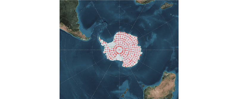
Fig 2
Antarctic sky view"
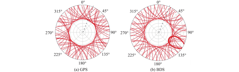
Fig 3
Number of GPS and BDS satellites visible in the polar regions during the observation period"
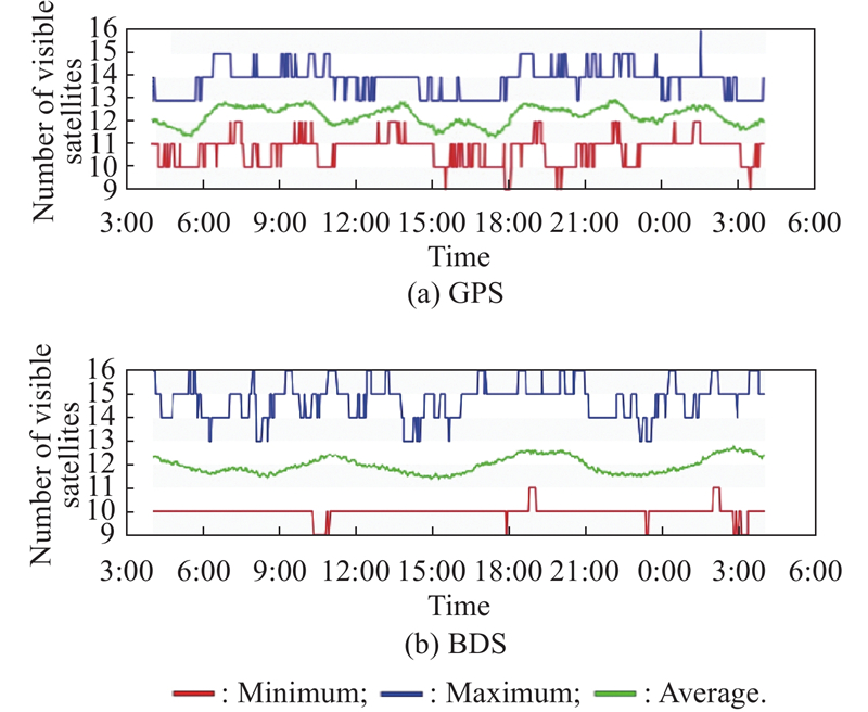
Fig 4
GPS and BDS systems’ PDOP values in the polar region"
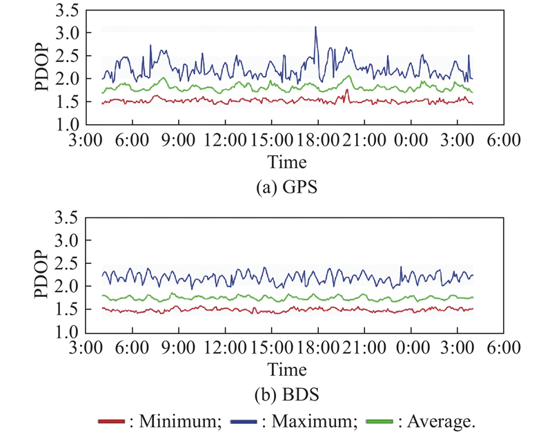
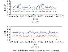
Fig 5
GPS and BDS systems’ GDOP values in the polar region"
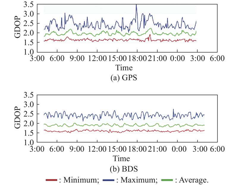
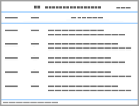
Table 1
Observation area PDOP, GDOP"
| Navigation system | PDOP | GDOP | |||||
| Maximum value | Average value range | Minimum value | Maximum value | Average value range | Minimum value | ||
| GPS | 3.153 | 1.688−2.071 | 1.422 | 3.591 | 1.805−2.216 | 1.507 | |
| BDS | 2.449 | 1.606−1.823 | 1.397 | 2.771 | 1.758−2.068 | 1.491 |
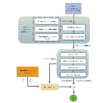
Fig 6
Gravity anomaly extraction model under Beidou signal"
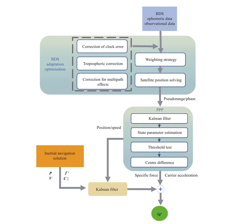
Fig 7
Algorithm flow for precision single-point acceleration estimation"
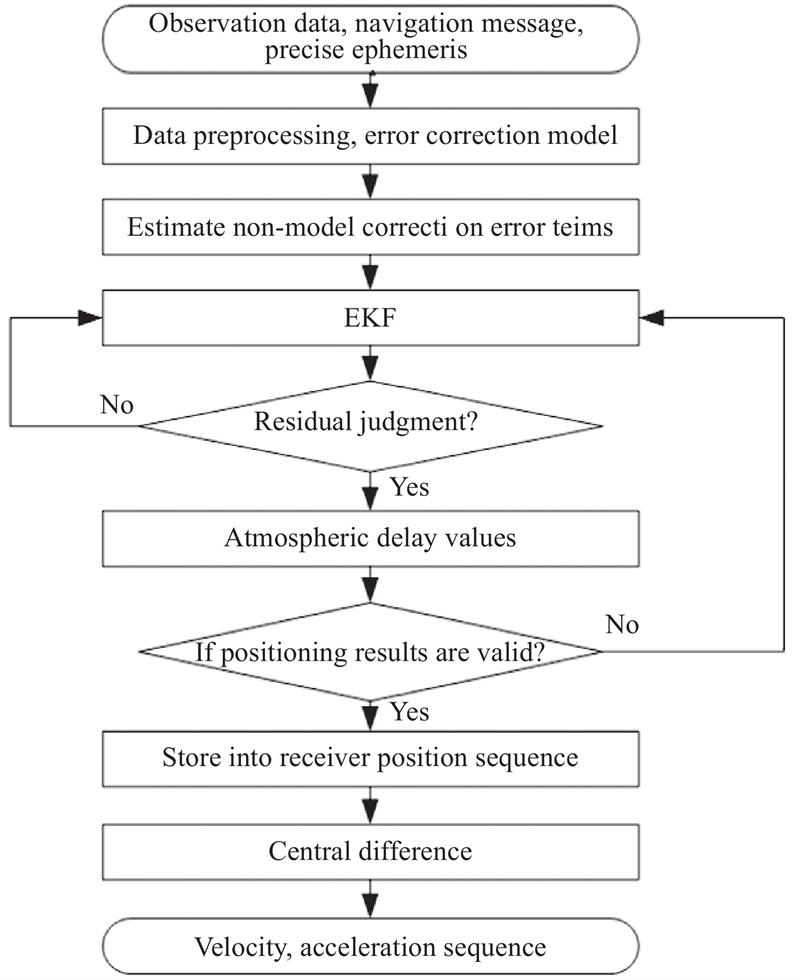
Fig 8
Gravity measurement flight paths and equipment loading"
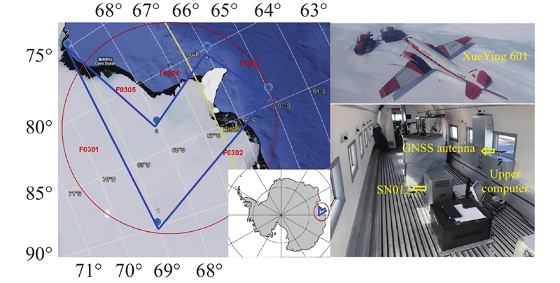
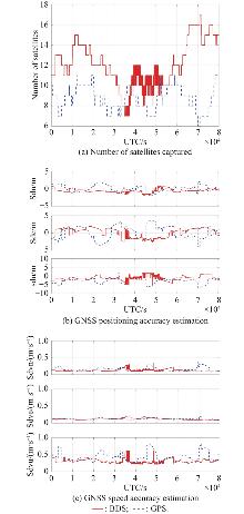
Fig 9
Number of satellites captured, estimation of position, and speed accuracy in polar regions using PPP solution"
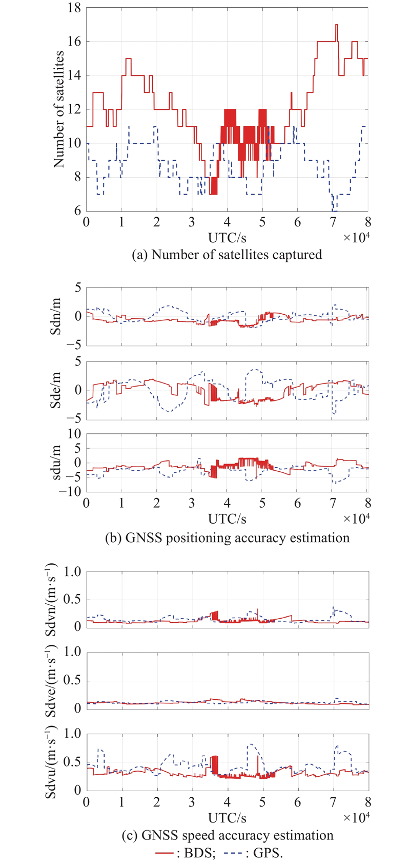
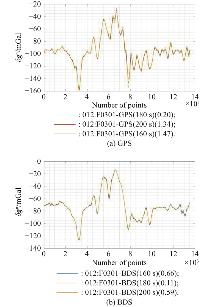
Fig 10
Gravity anomaly results based on BDS/GPS extraction (survey line F0301)"
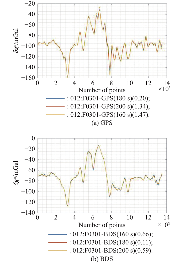
Fig 11
Gravity anomaly results based on BDS/GPS extraction (survey line F0302)"
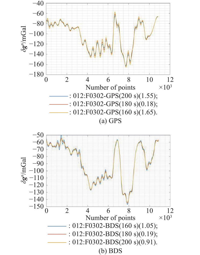
Fig 12
Gravity anomaly results based on BDS/GPS extraction (survey line F0303)"
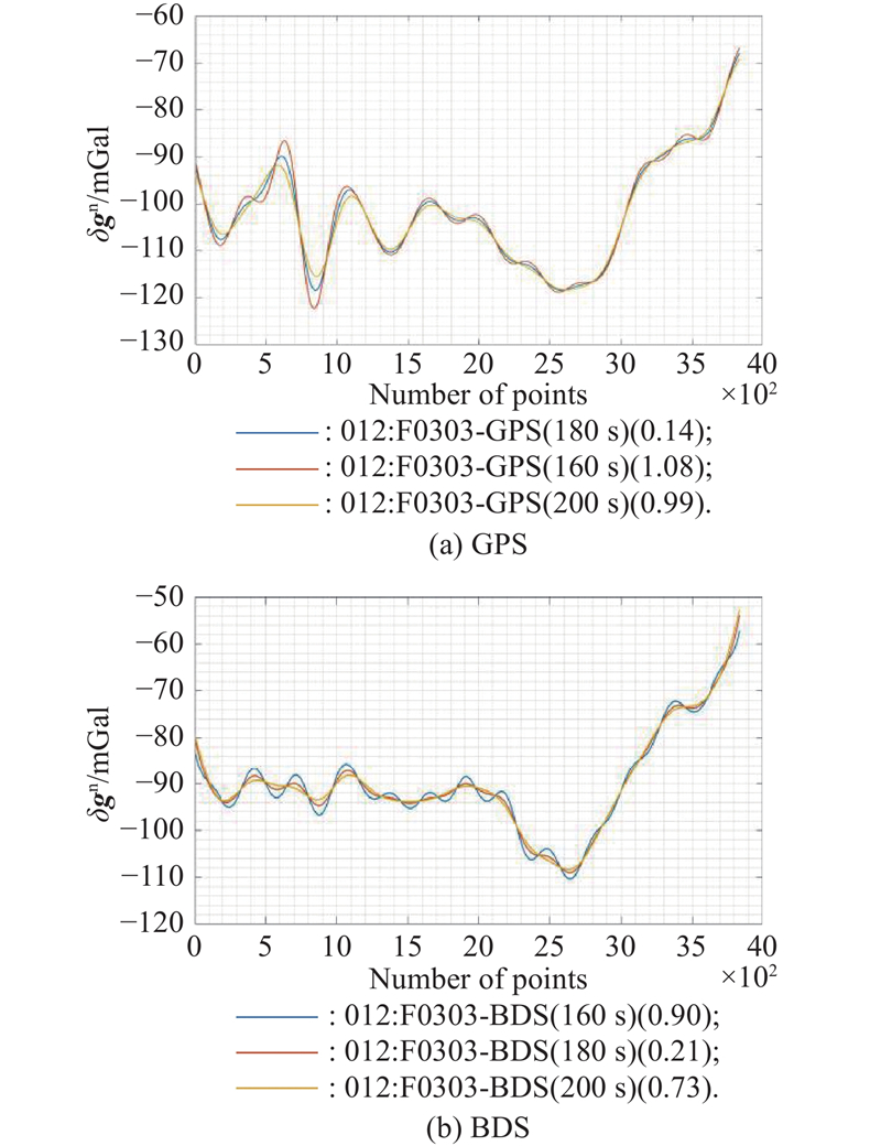
Fig 13
Gravity anomaly results based on BDS/GPS extraction (survey line F0304)"
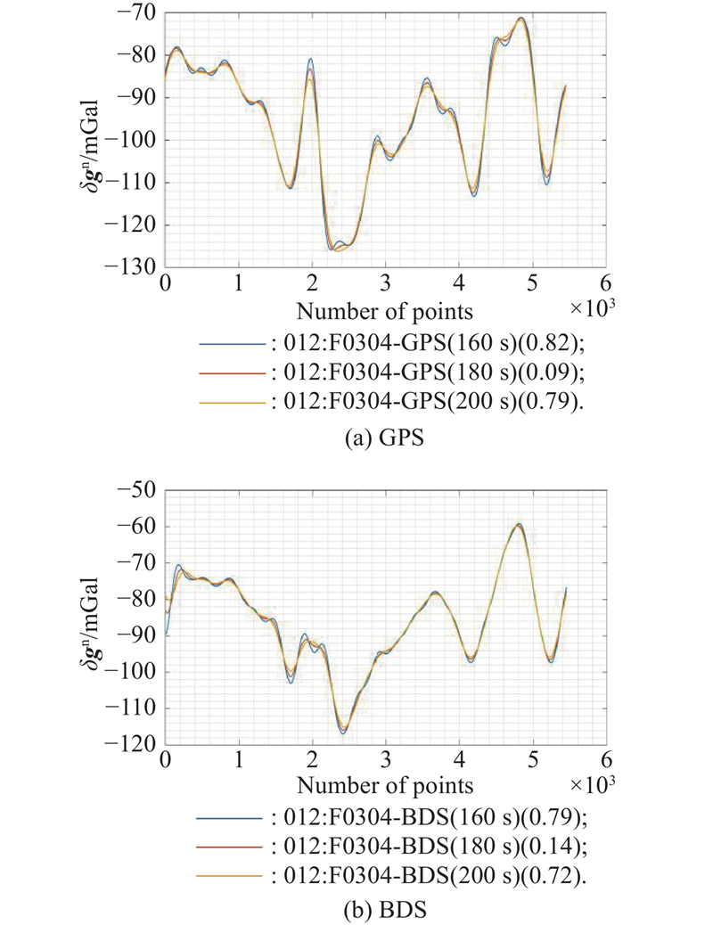
Fig 14
Gravity anomaly results based on BDS/GPS extraction (survey line F0305)"
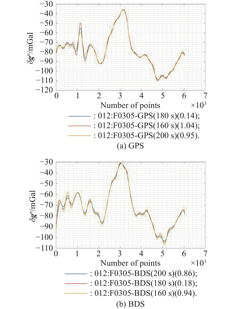
Table 2
Statistics on the accuracy of conformity within gravity anomalies extracted based on BDS/GPS mGal"
| Test line | RMS | |
| GPS | BDS | |
| F0301 | 1.15 | 0.51 |
| F0302 | 1.31 | 0.81 |
| F0303 | 0.85 | 0.68 |
| F0304 | 0.66 | 0.62 |
| F0305 | 0.82 | 0.74 |
| Mean | 0.96 | 0.67 |
| MSE | 0.056 | 0.011 |
| 1 | Pang X P, Ji Q, Cui X B, et al Current status and prospect of airborne earth observation in the polar regions. Ship & Boat, 2023, 34 (1): 20. |
| 2 | Pappa F, Ebbing J Gravity, magnetics and geothermal heat flow of the Antarctic lithospheric crust and mantle. The Geochemistry and Geophysics of the Antarctic Mantle, 2023, 56, 213. |
| 3 | Qiao G, Hao T, Li H W, et al Remote sensing and observation validation of key parameters of the polar ice sheet in the context of global climate change. Acta Geodaetica et Cartographica Sinica, 2022, 51 (4): 599. |
| 4 |
Lin C A, Chiang K W, Kuo C Y, et al Development of INS/GNSS UAV-Borne Vector Gravimetry System. IEEE Geoscience and Remote Sensing Letters, 2017, 14 (5): 759.
doi: 10.1109/LGRS.2017.2679120 |
| 5 | Wu Y H, Li Y, Jia D Z, et al Seamless seafloor topography determination from shallow to deep waters over island areas using airborne gravimetry. IEEE Trans. on Geoscience and Remote Sensing, 2023, 61, 1. |
| 6 | Li X, Dong J, Zhang W, et al Application of airborne geo- physical survey in Antarctica. Geophysical and Geochemical Exploration, 2022, 46 (1): 12. |
| 7 | Liu Z K, Li J C, Zhang X et al Method and analysis of acceleration determination using stand-alone GPS receiver for air- borne scalar gravimetry. Geomatics & Information Science of Wuhan University, 2019, 44 (5): 661. |
| 8 | Ma X T, Shi Z K, Qiang Z Y, et al Accuracy of precise timing based on uncombined precise point positioning algorithm in BeiDou navigation satellite system. Journal of Electronics & Information Technology, 2022, 44 (9): 3203. |
| 9 | Xu J C, Guo H, Huang J P, et al Integration and application of differential GPS positioning system in helicopter airborne gravimetry system. Navigation and Control, 2024, 23 (101): 95. |
| 10 | Xu W, Jia X, Qiao F, et al Basic positioning performance evaluation of BeiDou in the Arctic and Antarctic regions. Journal of Geodesy and Geodynamics, 2018, 38 (12): 1268. |
| 11 | Zhao J, An J C, Ai S T, et al Analysis of BDS-3 signal quality and basic positioning service around Antarctica. Chinese Journal of Polar Research, 2021, 33 (3): 370. |
| 12 | Zhang F, Jia X L, Ruan R G, et al. Positioning performance analysis of GNSS in polar regions[C]//14th China Satellite Navigation Conference, 2023. DOI: 10.26914/c.cnkihy.2024.000122. |
| 13 | Cheng J H, Li Z X, Liu J X Performance analysis of polar global navigation satellite system based on precise ephemeris. Science Technology and Engineering, 2022, 22 (8): 3020. |
| 14 | Sun Y C, Feng Y X, Cui X B, et al Application analysis of domestic aviation gravimeter in Antarctic area. Marine Surveying, 2022, 42 (3): 9. |
| 15 |
Liu P, Ling K V, Qin H L, et al Performance analysis of real-time precise point positioning with GPS and BDS state space representation. Measurement, 2023, 215, 112880.
doi: 10.1016/j.measurement.2023.112880 |
| 16 | Xiu R, Xue Z B, Jiang Z, et al A new domestic airborne gravimetry system. Navigation and Control, 2024, 23 (1): 24. |
| 17 |
Shi Y L, Xu T H, Li M, et al Real-time precise orbit determination of low earth orbit satellites based on GPS and BDS-3 PPP B2b service. Remote Sensing, 2024, 16 (5): 833.
doi: 10.3390/rs16050833 |
| 18 |
Shi Z M, Liang X H, Liu J Z, et al Gravity gradient model of the Antarctic region derived from airborne gravity and DEM. Earth, Planets and Space, 2025, 77 (1): 1.
doi: 10.1186/s40623-024-02131-3 |
| 19 | Wu M P, Cai S K, Yu R H, et al Research progress on strapdown gravimetry technology. Navigation and Control, 2020, 19 (Z1): 161. |
| 20 | Liu Y, Wang H, Gao H Y, et al Comparison of the accuracy of the calculation results of the tropospheric delay correction model. Beijing Surveying and Mapping, 2023, 37 (6): 829. |
| 21 |
Li W, Yuan Y B, Qu J K, et al New versions of the BDS/GNSS zenith tropospheric delay model IGGtrop. Journal of Geodesy, 2015, 89 (1): 73.
doi: 10.1007/s00190-014-0761-5 |
| 22 | Dong J Q, Guo J, Li G C, et al Influence analysis of different tropospheric models on airborne precise point positioning. Global Positioning System, 2022, 47 (6): 9. |
| [1] | Min Duan, Xiaopeng Li, Lei Huang, Meng Hua, Qiang Li. 2D-DOA estimation for NLOS environments via intelligent reflecting surface [J]. Journal of Systems Engineering and Electronics, 2026, 37(4): 1151-1160. |
| [2] | Xinyong ZHANG, Zhangming HE, Xuanying ZHOU, Huiyu CHEN, Jiongqi WANG, Haiyin ZHOU. Evaluation approaches for spatial targets localization precision based on observation matrix condition number [J]. Journal of Systems Engineering and Electronics, 2026, 37(2): 445-454. |
| [3] | Shijie DENG, Yingxin KOU, Maolong LYU, Zhanwu LI, An XU. λ-return-based aircraft maneuvering for terminal defense and positioning guidance strategies [J]. Journal of Systems Engineering and Electronics, 2025, 36(6): 1692-1708. |
| [4] | Xuefen ZHU, Ang LI, Yimei LUO, Mengying LIN, Gangyi TU. A tracking algorithm based on adaptive Kalman filter with carrier-to-noise ratio estimation under solar radio bursts interference [J]. Journal of Systems Engineering and Electronics, 2025, 36(4): 880-891. |
| [5] | Yu LU, Jiongqi WANG, Zhangming HE, Haiyin ZHOU, Yao XING, Xuanying ZHOU. System error iterative identification for underwater positioning based on spectral clustering [J]. Journal of Systems Engineering and Electronics, 2024, 35(4): 1028-1041. |
| [6] | Yao XING, Jiongqi WANG, Zhangming HE, Xuanying ZHOU, Yuyun CHEN, Xiaogang PAN. TOA positioning algorithm of LBL system for underwater target based on PSO [J]. Journal of Systems Engineering and Electronics, 2023, 34(5): 1319-1332. |
| [7] | Shuang CONG, Xiang ZHANG, Shiqi DUAN. Design and simulation of the ATP system considering the advanced targeting angle in quantum positioning system [J]. Journal of Systems Engineering and Electronics, 2022, 33(5): 1227-1236. |
| [8] | Yu LI, Honglan WU, Youchao SUN. Improved adaptive genetic algorithm based RFID positioning [J]. Journal of Systems Engineering and Electronics, 2022, 33(2): 305-311. |
| [9] | Zhuxian ZHANG, Yu ZHENG, Linhua ZHENG, Peidong ZHU. Range resolution and sampling frequency trade-off for GPS passive radar [J]. Journal of Systems Engineering and Electronics, 2022, 33(1): 28-37. |
| [10] | Hao ZHANG, Bin CUI, Zhichao GUAN, Han DUN. Comparison of density and positioning accuracy of PS extracted from super-resolution PSI with those from traditional PSI [J]. Journal of Systems Engineering and Electronics, 2021, 32(6): 1318-1324. |
| [11] | Sansheng WANG, Mingji ZHANG, Ning ZHANG, Qiang GUO. Calculation and correction of magnetic object positioning error caused by magnetic field gradient tensor measurement [J]. Journal of Systems Engineering and Electronics, 2018, 29(3): 456-461. |
| [12] | Jianing WANG, Baowang LIAN, Zhe XUE. Weak GPS signal acquisition method based on DBZP [J]. Journal of Systems Engineering and Electronics, 2018, 29(2): 236-243. |
| [13] | Ying Xia, Zhongzhao Zhang, and Lin Ma. Radio map updated method based on subscriber locations in indoor WLAN localization [J]. Systems Engineering and Electronics, 2015, 26(6): 1202-1209. |
| [14] | Yuhang Liu, Mingfa Zhu, and Limin Xiao. Elastic pointer directory organization for scalable shared memory multiprocessors [J]. Journal of Systems Engineering and Electronics, 2014, 25(1): 158-167. |
| [15] | Zhiliang Fan1, Guangbin Liu1, Xiaosheng Si1,2,*, Qi Zhang1, and Qinghua Zhang3. Degradation data-driven approach for remaining useful life estimation [J]. Journal of Systems Engineering and Electronics, 2013, 24(1): 173-182. |
| Viewed | ||||||
|
Full text |
|
|||||
|
Abstract |
|
|||||
